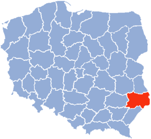
Zamość Voivodeship
Appearance
This article needs additional citations for verification. (April 2025) |

Zamość Voivodeship (Polish: województwo zamojskie) was a unit of administrative division and local government (voivodeship) in Poland in years 1975–1998,[1] superseded by Lublin Voivodeship.
Its capital and largest city was Zamość (population 65,021[2]). Other cities in the voivodeship included Biłgoraj (27,290[3]), Tomaszów Lubelski (18,396[4]), and Hrubieszów (15,925[5]).
See also
[edit]References
[edit]- ^ Czerny, Miroslawa (2006). Poland in the Geographical Centre of Europe. Nova Publishers. pp. 56–57. ISBN 9781594546037.
- ^ "Zamosc Population 2025". worldpopulationreview.com. Retrieved 2025-04-08.
- ^ "Place Rankings - Data Commons". datacommons.org. Retrieved 2025-04-08.
- ^ "Tomaszów Lubelski (lubelskie) » mapy, nieruchomości, GUS, noclegi, szkoły, regon, atrakcje, kody pocztowe, wypadki drogowe, bezrobocie, wynagrodzenie, zarobki, tabele, edukacja, demografia". Polska w liczbach (in Polish). Retrieved 2025-04-08.
- ^ "Hrubieszów (Urban Commune, Poland) - Population Statistics, Charts, Map and Location". citypopulation.de. Retrieved 2025-04-08.
50°43′14″N 23°15′31″E / 50.720556°N 23.258611°E

